A prolonged stretch of volatile spring weather has gripped large portions of the central United States, and the situation is far from over. Starting midweek and expected to last through early next week, this extended severe weather outbreak is putting millions at risk across the Midwest and Plains.
What’s Fueling This Outbreak?
Several key ingredients are combining to trigger these storms — warm, moist air from the Gulf of Mexico, a powerful jet stream overhead, and sharp frontal boundaries. These factors are helping to ignite supercell storms capable of producing tornadoes, damaging winds, and large hail.
Storm Impacts Across the Midwest
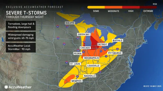
On Thursday night, Michigan was hammered by intense storms. Grand Rapids and surrounding areas experienced wind gusts near 80 mph and hail as large as golf balls. The I-94 corridor saw multiple tornado warnings and widespread power outages due to downed trees and power lines.
Chicago and other parts of northern Illinois and Wisconsin were also placed under elevated threat levels by the Storm Prediction Center, with the potential for strong EF2+ tornadoes.
Tornadoes Already Reported in the Central Plains
Nebraska and Kansas were the first to see tornado activity during this outbreak. Landspout tornadoes were observed in central Nebraska midweek, signaling the beginning of the multi-day threat. These initial storms served as a warning of what’s to come.
Texas and Oklahoma on High Alert This Weekend
Heading into the weekend, attention shifts to North and Central Texas, including major metro areas like Dallas, Fort Worth, Waco, and San Antonio. Severe thunderstorms are forecast to develop Friday through Sunday, with large hail (over 2 inches), tornadoes, and damaging winds all possible.
As the system tracks further south, Austin and even parts of southern Texas may also see impacts by Sunday night.
This Is Not a One-Day Event
Unlike typical spring storms that pass quickly, this is a prolonged weather pattern with multiple waves of severe weather. Each day, new areas are expected to be at risk, making ongoing vigilance essential for residents across a wide region.
Flash Flooding Another Major Threat
In addition to tornadoes and large hail, heavy rainfall will lead to localized flash flooding, particularly in urban areas or regions with saturated ground. Never drive through flooded roadways. Flash flooding can occur suddenly and be just as dangerous as tornadoes.
Stay Alert and Be Prepared
Local officials and forecasters strongly advise residents to:
-
Keep a weather radio or alert app active — especially at night.
-
Know where your safe space is (basement, interior room, or storm shelter).
-
Avoid staying in mobile homes during severe weather — make shelter plans ahead of time.
-
Create an emergency kit with water, food, flashlights, and essential supplies.
Severe Threat Continues Into Next Week
The threat isn’t expected to taper off soon. Early next week, the central and southern Plains — including parts of Oklahoma, Missouri, and Arkansas — could see another round of severe storms. With the jet stream remaining active and Gulf moisture persisting, storm chances remain elevated.
Peak Tornado Season Far From Over
Spring 2025 has already proven highly active. Tornado season typically peaks in May and June, and this year is following that pattern. Some meteorologists also point to shifting climate trends, with tornado activity appearing to extend farther east and later into the season.
Final Thoughts: Don’t Let Your Guard Down
This severe weather siege is not a drill. Communities across the Midwest and Plains need to remain alert, prepared, and responsive to changing forecasts. Stay informed through trusted weather sources, review your emergency plans, and check on family, neighbors, and those in vulnerable situations.
The Editorial Team
We are a collective of tech enthusiasts and digital experts dedicated to making sense of the evolving digital landscape for our global audience.
Connect With Us

0 Perspectives